Click for a downloadable River Map. Yampa River Guides are a FREE, downloadable series of map guides in PDF format, designed for recreational boaters on the Yampa River. DOWNLOAD HERE
Or call us to request your FREE Yampa River Map! Provided by Moffat County Tourism
Floating the Yampa River- Steamboat Springs to Cross Mtn. Canyon
The Yampa is considered one of the last free flowing rivers in the west, and although there are impoundments on the upper stretch of river, the majority is open to floating. Users need to understand that the majority of the Yampa River also flows through private property so floaters need to know where they can and cannot stop or touch bottom. Please respect private
property and utilize responsible river etiquette to promote being a responsible river user.
The following information is provided to assist you when recreating on the Yampa River. This should be combined with the appropriate maps and guides to ensure you have a safe and enjoyable experience. This guide will focus on the Yampa River from Steamboat to Deer Lodge in Dinosaur National Monument.
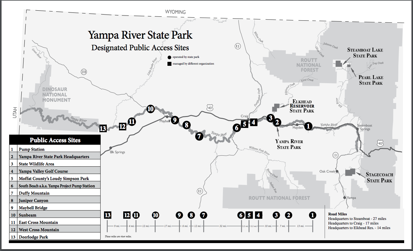
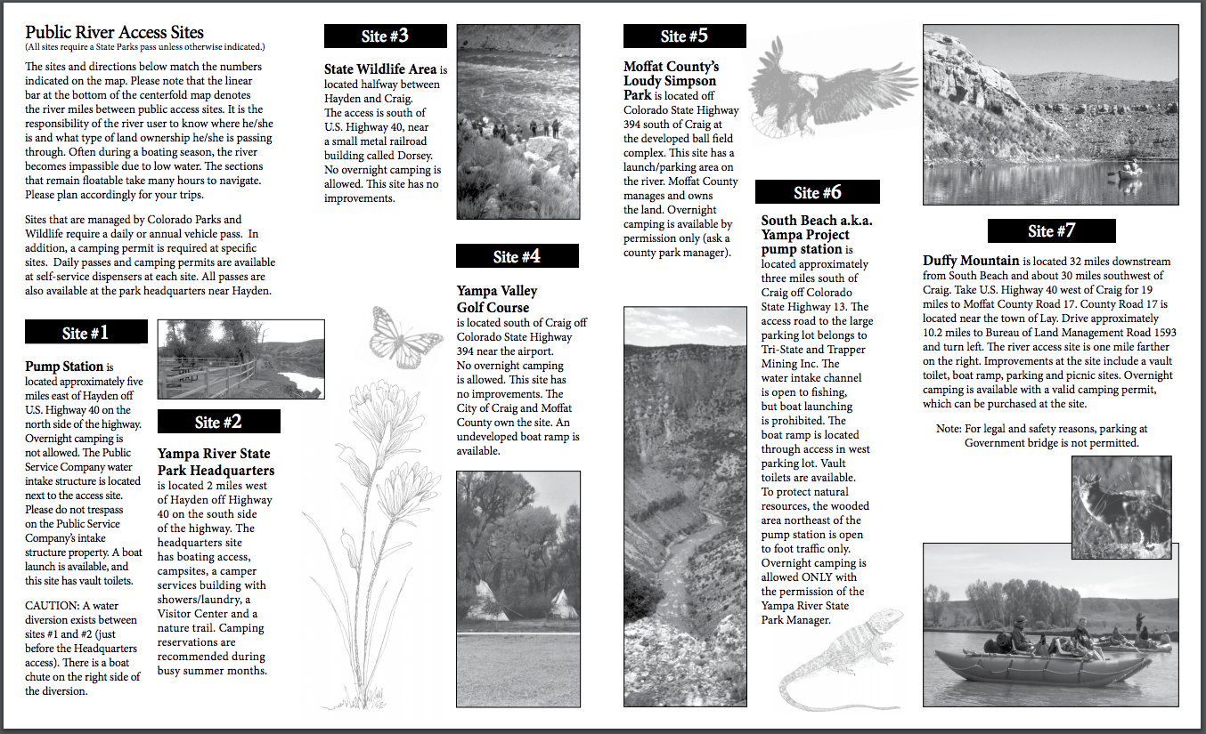
Steamboat to Pump Station: The first section is approximately 27 miles depending on launch location (in the Steamboat Springs area) and users must consider flows before attempting this float. The entire float passes through private property with no access or egress along the river. This is a flat water float with 2 diversion dams and 6 bridges along the way. At low levels, this is impassable in a boat and trespass is strictly enforced. At high flows, users need to be cautious of bridge clearances. This stretch of river provides a good fishing opportunity and a variety of watchable wildlife viewing as well. The take out for this float would be the Pump Station, managed through Yampa River State Park and Colorado Parks and Wildlife. Yampa River State Park has attempted to mark the river with red (private land-no access) and blue (public access allowed) signage along the river. A good map or GPS will ensure property ownership as well. DOWNLOAD MAP FOR THIS SECTION HERE
Pump Station to Yampa River State Park Headquarters: Pump Station to Yampa River State Park Headquarters, is 13 miles and primarily flows through private property. There is one section of publicly accessible property on the upper stretch (approximately 3.5 miles from the put in). This stretch flows through one of the most intact riparian ecosystems in the west and should be treated delicately. This float offers a good fishing opportunity, but the watchable wildlife opportunity is what stands out. Floaters will see a number of different bird species from Sand hill Cranes and Herons to Bald Eagles and Owls. Waterfowl and shore birds as well as Sharp tail grouse and possibly Sage grouse also exist. Nesting birds can be found along this float, with many nesting eagles and 2 large Heron rookeries. This is another reason to stay in your boat and be a discrete photographer. There is one constructed diversion dam at the end of your flow above the Yampa River State Park Headquarters takeout…run this river right and it is passable down to about 400cfs. The take out is on river right approximately one-half mile past the diversion. Along this stretch of river you will encounter 4 bridges. The last 2 (Hwy 40 & rail road) are very close together, and boats should use caution due to strong currents. The Yampa River State Park Headquarters offers camping with full amenities, and is a great launch for a multiday trip. DOWNLOAD MAP FOR THIS SECTION HERE
Yampa River State Park Headquarters to Dorsey: Yampa River State Park to Dorsey is a 7 mile stretch. This float is primarily through private property. The Dorsey Area offers river bank access and can be used by floaters along the trip. Red and blue signage can be found on this site, and once again, a good map or GPS will indicate property ownership. This float offers a good fishing opportunity with very good bird and wildlife viewing as well. There are nesting eagles and ospreys adjacent to the river, so please be sensitive to these nests in order to ensure future nesting. The takeout is a concrete ramp on river right. The river will take you very close to the railroad tracks…then look downstream for the large Cottonwood trees that are next to the ramp. DOWNLOAD MAP FOR THIS SECTION HERE
Dorsey to the Craig Golf Course (Pebble Beach): This is a 10 mile stretch from the Dorsey to the Craig golf course- aka Pebble Beach. This float is entirely through private property so please respect landowners. This is a flat water float that provides a great opportunity for families and those new to boating. This section does collect a large volume of downed trees, so watch for hazards (strainers) along the way. The take out is river left and is on the pebble beach, not a developed ramp. DOWNLOAD MAP FOR THIS SECTION HERE
Craig Golf Course (Pebble Beach) to Loudy Simpson Park: This is a 3.5 mile stretch from“Pebble Beach” to Loudy Simpson Park. A fish-friendly, in-channel recreational water feature has recently been constructed near Craig's municipal water intake structure. The existing degraded municipal water intake diversion dam has been reconstructed to include two navigable whitewater drop structures with associated fish passage structures. The play feature is designed to provide a moderate whitewater opportunity for a broad variety of river recreationalists at varying flow levels. Riverward improvements include 2 small amphitheater structures planned for the riverbank and associated eddy/swimming/wading areas; these will be family friendly and appropriate for environmental education activities. TO BE COMPLETED OCTOBER 2025! Upland-based amenities will be constructed adjacent to the water feature to create the beginnings of an integrated river park complex. This component will include a gravel access road, parking areas, walking trails and river access for anglers and small watercraft (kayaks, paddle boards, inner tubes). All features are being designed to provide family-friendly river access for park users and to protect municipal water supply infrastructure. TO BE COMPLETED OCTOBER 2025! This short float is popular with tubers and families. There is a rock diversion located just below the golf course, so be very cautious. The take out is river left just below the Ranney Street bridge. DOWNLOAD MAP FOR THIS SECTION HERE
Loudy Simpson Park to South Beach: This 5.5 mile float takes you from Loudy Simpson to South Beach. Once you get below Loudy Simpson Park you enter private lands until you cross under the Hwy 13 bridge. There are 2 bridges on this stretch, and the upper railroad bridge does collect debris so floaters should stay clear. Once downstream of the second bridge, floaters can access the river on the left side. Please do not take boats out at the power plant pump intake; the ramp is river left below the pump intake and parking area. DOWNLOAD MAP FOR THIS SECTION HERE
South Beach to Duffy Mountain (Little Yampa Canyon): This float is 33 miles from South Beach to Duffy Mountain, and is perfect for a one or two night trip (all flat water). Within this section you have a variety of camping opportunities on BLM lands. Floaters must cover the first 7 miles before public access opportunity exists. This float has good hiking and wildlife viewing opportunities. There are scattered archeological sites along the way, so vigilant eyes on the rocks can discover old rock art. This area is checkered with private in-holdings, so the Little Snake Resource area BLM map is a great asset. The take out is river left just as you come out of the canyon. You will see the restroom and shade shelters on the site (camping is available here). Look for the Eagles nesting on river right near the take out. (See our Little Yampa Canyon page for more info) DOWNLOAD MAP FOR THIS SECTION HERE
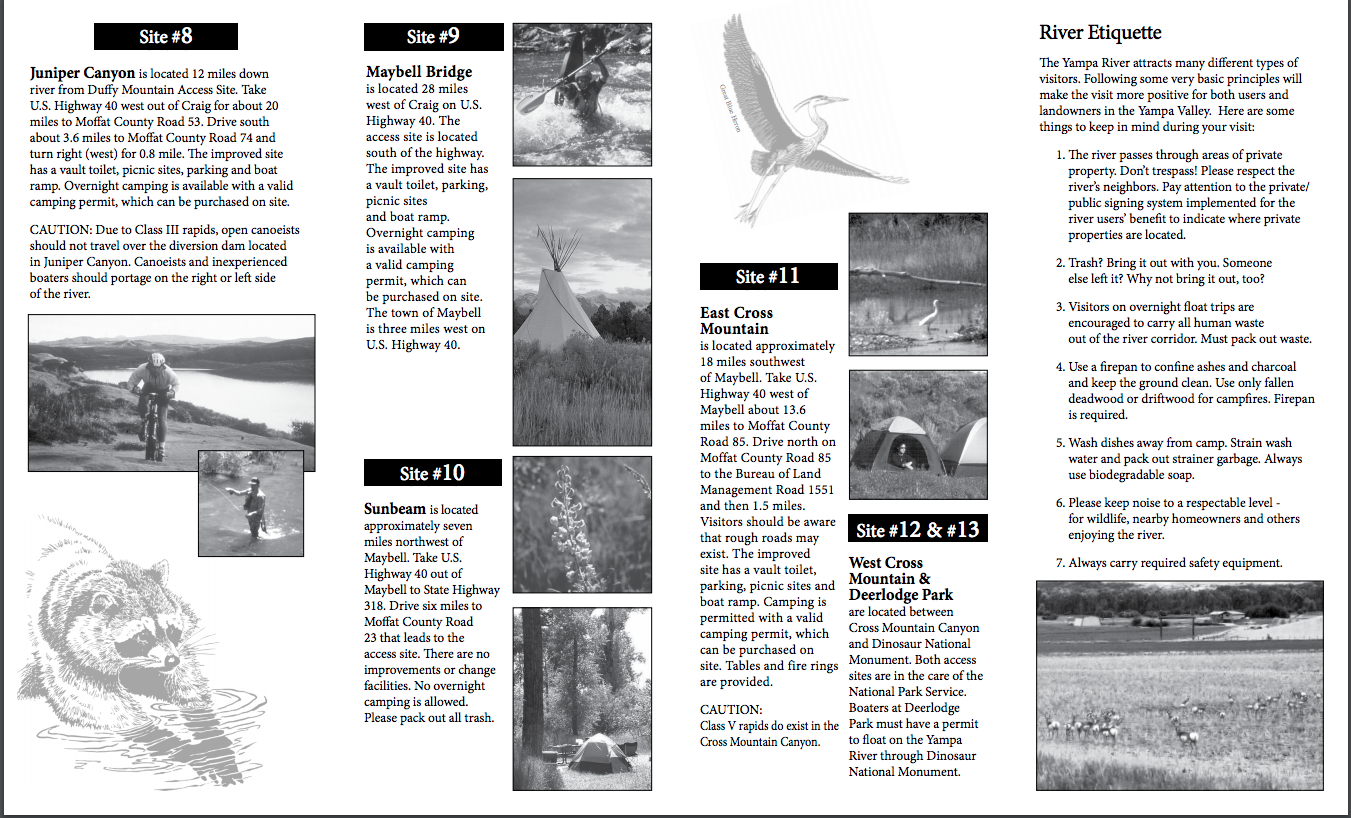
Duffy Mountain to Juniper Springs: This is a 12 mile flat water float from Duffy Mt. to Juniper Springs. This float is primarily through private land with a small diversion structure downstream of Government bridge (there is no access from this bridge), which is off of Moffat County Road 17. The takeout at Juniper Springs is river right. Look for the campground (the access is in the willows and can be difficult to see). You will pass under 2 bridges on this float so high water users should scout these as they run their shuttle. DOWNLOAD MAP FOR THIS SECTION HERE
Juniper Springs to Maybell Bridge (Juniper Canyon): This is a 6 mile run through Juniper Canyon from Juniper Springs to Maybell Bridge. This float contains the first true drop on this stretch of river. As boaters enter the canyon they will see the horizon line of the diversion. Pull out river right to scout it far enough upstream so as not to get pulled into the head gate. This is a class III run most of the time, but can vary with flows. A nice wave train below the diversion takes you through the rest of Juniper Canyon, where you pass under the flume and out of the canyon. The remainder of the float passes through private land until the take out. As you round the corner and see the Hwy 40 bridge, the take out is river right. Stay close to the bank so you don’t miss it in the willows. There are campsites and rest room facilities at this access. Warning! The Maybell Ditch rapid in Juniper Canyon is a significant whitewater run, and should not be attempted by parties without whitewater skills and appropriate watercraft. Also be advised that portaging around the new diversion and headgate can be a difficult, time-consuming challenge. If you are not prepared to run the rapid, your best option is to take out at the Juniper Canyon boat ramp. DOWNLOAD MAP FOR THIS SECTION HERE
Maybell Bridge to Sunbeam: This 17 mile float from Maybell Bridge to Sunbeam runs through ranch lands and high desert. You will encounter 3 bridges to pass under (all have good clearance but caution is always advised). This stretch does offer a fair warm water fishing opportunity but this great flat water is idea for the touring kayak or canoe. The take out is river left just after you pass under the Hwy 318 bridge. DOWNLOAD MAP FOR THIS SECTION HERE
Sunbeam to East Cross Mountain: This 12 mile stretch from Sunbeam to East Cross Mountain is similar to the section upstream with high desert ranch land and great flat water boating. Kayaks and canoes are ideal for this stretch. The take out is river left and you get a big view of the Cross Mountain Canyon. Caution- below this is Class V water and there is no egress until the bottom of the canyon! DOWNLOAD MAP FOR THIS SECTION HERE
East Cross Mountain to Deer Lodge (Cross Mountain Canyon): This stretch is 4 miles of white water through Cross Mountain Canyon. It is recommended that you are a very proficient boater, as the water typically contains class IV or V rapids. There is no river bank access from the canyon, so boats must self support and self rescue. Spring can be a good time to access the canyon at more moderate levels before high runoff.